App Topo GPS
Welcome to Topo GPS, the ultimate navigation app designed for outdoor enthusiasts, hikers, and adventurers. With this innovative software, you have access to detailed topographic maps and a plethora of features that make your journeys safer, more enjoyable, and easier to manage.
What is Topo GPS?
Topo GPS is a mobile application available for both iOS and Android devices. Its primary function is to provide users with accurate topographic maps that offer comprehensive details about the terrain. From elevation changes to detailed trails, Topo GPS ensures you have all the information you need for a safe and successful outdoor experience.

Download Topo GPS for Mobile
 Download
Features of Topo GPS
Topo GPS is loaded with a variety of features that cater to different types of outdoor adventures. Here’s a breakdown of some of the key features:
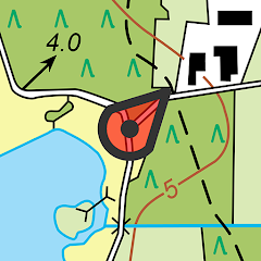
Interactive Maps
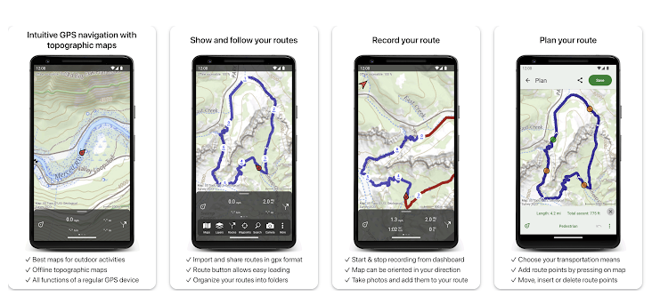
Topo GPS provides highly detailed topographic maps. These maps are interactive, allowing users to zoom in for more detail or zoom out to get a broader perspective.
Waypoints and Routes
- Create and save waypoints
- Plan and design custom routes
- Import and export GPX files
With these functionalities, you can chart your entire journey before setting out, ensuring nothing is left to chance.
Real-Time Navigation
Real-time GPS navigation makes it easy to stay on track. With your current location always displayed on the map, you can easily navigate even the most complex trails. The app also offers multiple navigation modes, catering to different needs.
One of the standout features of Topo GPS is its ability to download maps for offline use. This ensures you remain on course even when you’re off the grid and lack internet connectivity.
Customizable Settings
- Adjust map types and layers
- Personalize units of measure
- Configure notifications and alerts
These settings allow you to tailor the app to your specific needs, making each journey more intuitive and personalized.
Why Choose Topo GPS?
Topo GPS stands out from other navigation apps due to its comprehensive set of features and focus on user experience. Below are some reasons why it's a must-have for any outdoor adventure:
Accuracy and Detail
The app uses high-quality topographic maps that give you precise details of the terrain, ensuring you can navigate with confidence.
User-Friendly Interface
Despite its robust set of features, Topo GPS boasts an intuitive interface that makes it easy to use for beginners and experts alike.
Reliability
With offline map functionality and real-time GPS tracking, you can rely on Topo GPS even in challenging environments.
Community and Support
The app has a strong community of users who share routes and tips. Additionally, the support team is responsive and eager to assist with any issues you may encounter.
Download Topo GPS for Mobile
Download
Getting Started with Topo GPS
Starting your journey with Topo GPS is simple. Follow these steps:
- Download the app from Google Play Store or Apple App Store.
- Create an account or log in if you already have one.
- Familiarize yourself with the interface through the quick start guide.
- Download necessary maps for your destination.
- Customize settings to match your preferences.
- Plan your route and save waypoints.
- Enable real-time GPS tracking and start your adventure.
Future Enhancements
At Topo GPS, we’re continually looking to improve our app and offer even more features to our users. Some upcoming enhancements include:
- Integration with wearable devices
- Enhanced social sharing features
- Additional map types and enhanced detail options
- AI-based route recommendations
With its array of features, user-friendly interface, and reliable performance, Topo GPS is the ultimate navigation tool for anyone serious about outdoor adventures. Whether you're hiking, biking, or exploring seldom-trodden paths, this app offers everything you need to make your journey as smooth and enjoyable as possible. Download Topo GPS today and take the first step towards a more adventurous and well-navigated life.
With its array of features, user-friendly interface, and reliable performance, Topo GPS is the ultimate navigation tool for anyone serious about outdoor adventures. Whether you're hiking, biking, or exploring seldom-trodden paths, this app offers everything you need to make your journey as smooth and enjoyable as possible. Download Topo GPS today and take the first step towards a more adventurous and well-navigated life.
The Topo GPS app is a powerful tool for outdoor enthusiasts, offering a range of features that can significantly enhance navigation and exploration experiences. In this comprehensive analysis, we'll delve into various use cases of the Topo GPS app, highlighting its capabilities and practical applications.
Introduction to Topo GPS
The Topo GPS app is designed to cater to the needs of hikers, trekkers, mountain bikers, and other outdoor adventurers. It provides precise topographical maps, offline navigation capabilities, and other tools to make outdoor journeys safer and more enjoyable.
Key Features of Topo GPS
The app comes equipped with a plethora of features that make it stand out. These include:
- High-quality Topographical Maps: Provides detailed maps that include elevation data, trails, and landmarks.
- Offline Navigation: Allows users to download maps and use them without an internet connection.
- Route Planning: Helps users plot routes with waypoints and measure distances accurately.
- GPS Tracking: Tracks and records your route in real-time.
- Waypoint Management: Allows for adding, saving, and editing waypoints for easy navigation.
Hiking and Trekking
The Topo GPS app is particularly beneficial for hikers and trekkers. Let's examine a few scenarios where the app proves indispensable:
Planning a Hiking Trip
Planning a hike can be daunting, especially in unfamiliar terrain. The Topo GPS app simplifies this process by enabling users to:
- Select a region and download its topographical map.
- Identify and mark points of interest, such as campsites and water sources.
- Plot the optimal route, taking into account elevation changes and trail conditions.
During the Hike
While on the trail, hikers can use the Topo GPS app to:
- Navigate using real-time GPS data.
- Monitor their progress and ensure they remain on the planned path.
- Access offline maps in areas with no internet connectivity.
These features greatly enhance safety and ensure a more enjoyable hiking experience.
Mountain Biking
Mountain bikers can also derive immense value from the Topo GPS app. Here's how:
Trail Exploration
Mountain bikers often venture into less-traveled paths. The app helps them by:
- Providing detailed topographical maps that highlight suitable trails.
- Allowing the creation of custom routes to explore new areas.
- Offering real-time tracking to monitor speed and distance covered.
Offline Capabilities
In remote areas, the Topo GPS app's offline capabilities ensure that bikers can still navigate and explore without relying on cellular data.
Emergency Situations
The Topo GPS app can be a lifesaver in emergency situations by offering features such as:
Location Sharing
Users can share their real-time location with friends and family, ensuring that someone knows their whereabouts in case of an emergency.
Waypoint Marking
In case of an injury or emergency, users can mark their exact location and send it to rescuers, speeding up the response time.
Educational Purposes
The app is also useful for educational purposes. Educators and students can use it to:
Geography and Earth Sciences
Teachers can use the app's detailed maps to teach students about topography, geography, and earth sciences. Students can explore real-world data and understand the practical implications of theoretical concepts.
In conclusion, the Topo GPS app is a versatile tool that serves multiple purposes, from recreational activities like hiking and mountain biking to emergency situations and educational uses. Its comprehensive feature set, including high-quality maps, offline capabilities, and real-time tracking, makes it an indispensable companion for outdoor enthusiasts. Whether you're planning a trip, navigating trails, or teaching geography, the Topo GPS app offers valuable support and enhances your experience.